Introduction to the KRGJSH Networks
Approval of law no. 72.2012, “On the Organization and Operation of the National Geospatial Information Infrastructure in the Republic of Albania” which approximates the INSPIRE Directive 2007/2 EC of the European Parliament and the Council, as well as the creation of the State Authority for Geospatial Information ASIG, as the institution responsible for the implementation of of this law, laid the necessary legal and institutional foundations for the design, construction, maintenance and updating of the Geodetic Reference Frame (KRGJSH). The requirements set by the “INSPIRE” Directive for the definition of geoinformation in a European spatial reference, a reference which plays a basic role in the harmonization and interoperability related to the positioning of information, which is dealt with in the other 33 topics of the Directive, has become one of main commitments of ASIG. One of the first by-laws initiated by ASIG and approved by the Albanian government, in order to create a modern geodetic reference, with European standards, for all users of geodetic coordinates in Albania was VKM no. 669, dated 7.8.2013 “On the Approval of the Rules for the Determination, Creation and Implementation of the Albanian Geodetic Reference Framework (KRGJSH), as metadata”, amended by VKM no. 322, dated 27.04.2016 and VKM no. 359, dated 29.05.2019. This decision was followed by the approval of the Guide of the Minister of Innovation with No. 3, dated 06.09.2013 “On the determination of geodetic points with the help of Global Navigation Satellite Systems (GNSS)” and by the preparation of a more detailed standard on the subject “Determining the geodetic reference frame and geodetic control”. Based on these acts, the sector responsible for KRGJSH, next to ASIG, is engaged in the construction of networks composed of KRGJSH, combined between them, which must have common points, with existing geodetic networks in Albania and with existing networks that currently cover the territory of the European continent, to enable Albania to create a unique geodetic base that relies totally on GNSS technology for efficiently determining the exact horizontal and vertical position of various points on the earth’s surface, above and below its surface .
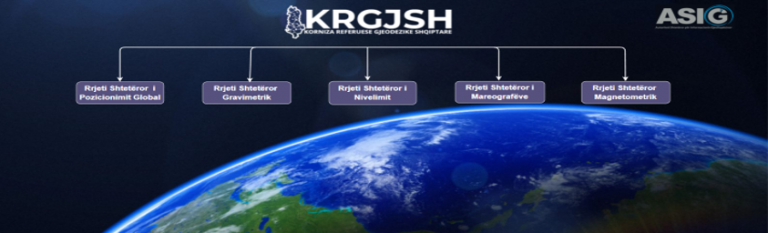
The unique geodetic base of the Republic of Albania includes the following networks:
1.State Global Positioning Network;
2.State Leveling network;
3.State gravimetric network;
4.State Tide Guage Network;
5.State Magnetometric Network.
ASIG in function of creating the component networks of KRGJSH during a period of almost 15 years has taken concrete steps, where until now it has successfully implemented most of the networks of KRGJSH and in the framework of the creation of the new vertical geodetic reference ASIG for the first time in RSH, in 2023, it realized the first version of the gravimetric geoid based on the terrestrial gravimetric data of the first three orders of the State Gravimetric Network.