GNSS Active State Network.
The active state network GNSS is represented by the GNSS ALBCORS network which enables a new realization of the Land System of the European Reference ETRS89 for the territory of Albania and at the same time serves for the maintenance of this reference for the territory of Albania.
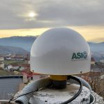
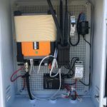
In the composition of this network we have 21 CORS Stations built with concrete blocks, 6 CORS (roof type) stations integrated by the old ALBPOS system and a control center located in the premises of ASIG.

- For the RTK method ± 2 – 3 cm;
- For the PP method ± 1 cm ;
The ALBCORS monitoring center program consists of four modules:
- Module for operation, control, administration and monitoring of CORS network reference stations and user management.
- Module for compensation and calculation of data (corrections) in real time.
- GNSS post-processing module.
- WEB page module.
- The program also enables:
- User registration.
- Download station data at different intervals (from 1-30 seconds) to RINEX format (versions 2 and 3).
- Realization of RTK solutions in the network and distribution of corrections in real time to users.
- Graphical representation of:
- Visual results (on monitor)
- Positioning users
- Satellite coverage for each station
- Corrections (ephemeris data, ionospher, multipath etc.
Also, this system guarantees a series of advantages in support of geodetic works in the territory of our country such as:
- Creating a Permanent (Dynamic) Geodetic Reference Conical
- Implementation and maintenance of ITRS / ETRS in Albania.
- It enables a stable and common reference for accurately collecting and creating geospatial information.
- Monitors tectonic activities and land stability in the Republic of Albania (in cooperation with IGJEUM).
- Provides measurable information on floods and natural disasters.
- Efficient and productive use of GNSS service for engineering work (Effective in time and cost).
- Serves for scientific purposes
GNSS Passive State Network;
The GNSS State Passive Network will consist of two orders:
GNSS Passive Network of the First Order
The points of the Passive State Network GNSS of the First Order consists of points located in such a way that together with the points of the State Network GNSS Active to ensure an almost uniform distribution in the territory of Albania. These points will be common points for all Networks of the First Network that has in its composition the Albanian Geodetic Reference Framework “KRGJSH”.
2. Second GNSS Passive Network
The GNSS Passive State Network of the Second Order serves to thicken the GNSS Passive Network of the First Order. Part of this network will be all the points of the basic local geodetic networks that will be built in the most important inhabited centers.